NCAS Weather Research Catalogue
NCAS weather research (NWR) is a real-time
weather forecasting and air quality forecast website for the United
Kingdom.
The weather forecasting section the site uses
the Weather Research and Forecasting (WRF) model which is a
state-of-the-art numerical weather prediction system designed for
community use. This is an open-source community model that was
developed principally by the United States National Center for Atmospheric Research (NCAR) and National Oceanic and Atmospheric Administration (NOAA).
The model is using version 3.7.1 , and the
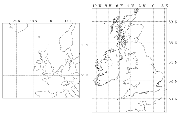
implementation of the WRF-ARW model consists of two domains. The
outermost domain d01 covers much of northwest Europe and the
eastern North Atlantic Ocean with a horizontal grid spacing of 20
km, and the innermost domain d02 covers much of the United Kingdom
and Ireland with a horizontal grid spacing of 4 km. Both domains
have 51 vertical levels and are run for 54 hours, initialized at
1800 UTC from the NOAA Global Forecast System (GFS), which also
provides lateral boundary conditions every 6 hours.
The Air Quality Forecast (AQF) section of
the site is run by the
Centre of Atmospheric and Instrumentation Research, University of
Hertfordshire and employs an
integrated modelling framework for producing operational air
quality forecasts based on WRF-CMAQ. Daily forecasts of up to three
days are performed for Europe and UK domains at a grid resolution
of 50km and 10km respectively (shown in the figure
below).
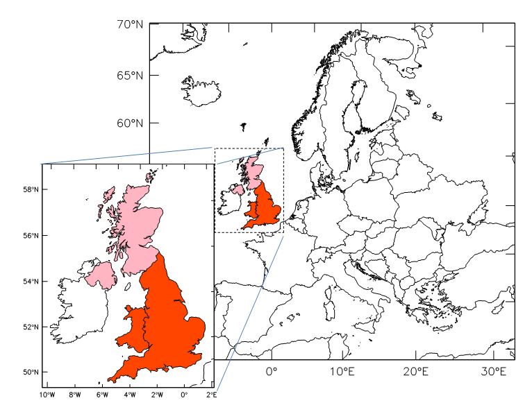
The outer domain, also known as
mother domain, provides the lateral boundary conditions to the
nested UK domain. There are a total of 24 vertical levels up to 10
hPa. The grid is stretched along the vertical axis to accommodate a
high resolution within the boundary layer (9 layers up to about
2000 m above ground-level) and close to the ground surface. Digital
elevation, soil type, land cover data, and the other
characteristics of the soil and the ground surface (e.g. monthly
surface albedo) are derived from the default geographical data that
is provided with the WRF pre-processing system.
Meteorological initial (ICs) and
lateral boundary conditions (BCs) of the outer domain are derived
from the National Centers for Environmental Prediction (NCEP) FNL
(Final) Operational Global Analysis data available every six hours.
Chemical boundary conditions are from MACC II (Monitoring
Atmospheric Composition and Climate) global forecast. The TNO
emission inventory is processed with the Sparse Matrix Operator
Kernel Emissions system adapted at CAIR for UK and European
domains. Biogenic emissions are generated with the Model of
Emissions of Gases and Aerosols from Nature (MEGAN) and CB05
chemical mechanism is used with a tri-modal approach to aerosol
size distribution to model particulate matter.